Vargo Outdoors Titanium Ti-Boiler
When is a pot, not a pot? – When it’s a mug obviously. And a pan? Well you just have to figure that one out for yourself.
…………But the Vargo Outdoors Titanium Ti-Boiler works well as all three. And as a bowl. And as a kettle. That kind of multi-purpose functionality is, gram for gram, just what we should demand from our outdoor, wild-country, back-country, backpacking gear …

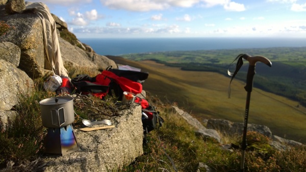
Vargo Outdoors Titanium Ti-Boiler – Sack ready after lunch in Baile na Móna (Ireland’s Ancient East).
Vargo Outdoors Titanium Ti-Boiler is born
Vargo Outdoors took their Ti-Lite 750ml mug. (The mug that thought it was a pot. Or is it a pot that thinks it’s a mug? Whatever, it has more fans than fireworks on halloween). Made it 20% bigger and called it the Vargo Outdoors Titanium Ti-900 Mug. Perfect for solo trekkers. Cleverly designed. Very well made. And conveniently easy to clean. There’s no doubt it’s: Trail ready.
But wait. There’s more…
Vargo watched for all those neat little tricks we long distance packers have: Using your plate as a pan lid to warm food. Frying sausages in your breakfast bowl. Foraging everything from blackberries to chestnuts with your cooking pot. Those “lets-make-do-and-go-light” strategies.
So aiming to give us that much-loved trail-flexibility
They revised their design of the Ti-900 mug lid and made it a 400ml pan. Or was it that they revised the design of a pan and made it a bowl. To be honest I’m not sure. But I am sure, that with these two pots together: The Ti-900 mug and the 400 ml pan, you can forage, boil, cook, fry, drink and eat.
185 grams of trail flexibility they call the Vargo Outdoors Titanium Ti-Boiler. Trail ready and trail flexible. Use each part individually or stacked together:
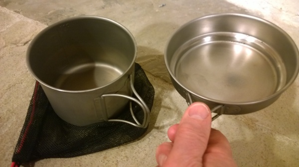
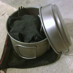
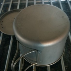
Vargo Outdoors Titaium Ti-Boiler : 900ml mug, 400ml pan & mesh stow bag
The 400 ml pan/lid
Pure titanium construction, designed and manufactured with the same care and attention evident in its partner the Ti-900 Mug. The pan features:
- A good compromise in the radius of the folds between the sides and the base: Easy cleaning, with a safe wobble-free fit to the mug. A roll of metal forms the lip, and makes it sturdy.
- Perfectly fitted butterfly pan handles, fold out and insulate even delicate hands. A neatly executed bracket ensures no slop, no rough edges and minimum deformation.
- Saving of weight: Substituting for this Ti-Boiler pan/lid for the lid of the Ti-900 mug takes an extra 55+ grams, but wins all the extra flexibility.
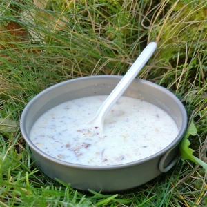
- Vargo Outdoors Titanium Ti-Boiler : Using the 400ml lid as a breakfast bowl
Cleaning
Cleaning the pan is as easy as cleaning the Ti-900 mug. Even the burnt oil and fried residue surrendered to the old trick of a little olive oil and a nylon pan scrubber, giving that light sheen.
Bio-compatible
The pan, like the mug, is bio-compatible. And using the burnt-oil stained pan to forage blackberries didn’t flavour them at all. Neither could I tell it was anything other than a breakfast bowl when I used its convenient 400 ml shape & size to eat my breakfast muesli.
Pro’s
- Trail Ready: Considered design. Quality materials and manufacture.
- Trail Flexible: Possible uses are well thought through. Both parts can work like pots, pans, mugs, lids, bowls and a kettle. Either together or apart. You can carry it empty for foraging. Or pack it with your micro stove and a 100g gas can for quick stop cooking.
- Easy to use, clean and carry: One less thing you have to think about on the trail.
- Ultra-light: Take it with the Vargo Titanium Hexagon Stove and utensils. You’ll still be carrying less than 350 grams with everything you need to cook, eat and drink.
Con’s
- In Europe, at least, titanium is not the cheapest option. But import duties aside, with the Vargo Titanium Ti-Boiler, you do get what you pay for. And the pleasure will be delivered to you slowly over time, day after day, on the trail.
Best uses
- Solo backpacking, trekking, general mountaineering.
- Hot meals & drinks solo day mountaineering or hill-walking
- Valuable in a two pot combo when duo/trio packing.
- Works with foraged fuel stoves, alcohol, pressurised petrol or propane/butane.
- Vargo Outdoors Titanium Ti-Boiler : Easily holds a 100g gas can & micro stove
Useful links
Web site: Vargo Outdoors
Product page:
The Titanium Ti-Boiler at Vargo Outdoors
Retailers
The Vargo Ti-900 Mug at UltralightOutdoorGear.co.uk
The Vargo Ti-Boiler at Amazon.com
Insane pricing alert:
The Vargo Ti-Boiler at Amazon.co.uk
.
.
.
Disclosure:
Supplied by Vargo and used for real, mainly with the Vargo Hexagon Wood Burning Stove
You can read My product review policy and practices.
A couple of images from the field


Sharing is brilliant. It rewards me for my effort and encourages me to do more. Please share...

Vargo Outdoors Titanium Ti-900 Mug
Simple design, well made, and fit for purpose. That’s what experienced backpackers, and wilderness adventurers want. Gear to use time after time, without need for a second thought. This Vargo Outdoors Titanium Ti-900 Mug is exactly that.
Vargo Outdoors Titanium Ti-900 Mug – Boiling up for coffee in the Mountains of Mourne
113mm diameter, 90mm high and a perfectly fitting lid that works brilliantly as a strainer. The two tight-fitting, fold-away, D-shape handles, remain cool enough for the bare hand when the pot is hot. It’s made entirely from pure titanium, except the heat-insulating “Bakelite” knob of the lid. And the measuring scale is easily readable, embossed clearly into the side of the mug.
It holds 900 ml of water which is the right size for the water-boiling and food-cooking needs of most solo and duo backpackers. And it works well with the current generation of micro-stoves including the Vargo Hexagon Wood Burning Stove.
And very important, being completely bio-compatible, I found there was no impact on the flavour of any of the main brands of Irish whiskey when drunk from the mug. And, of course, no affect on the taste of any cooked food. All this for a pot that weighs 92/28/14 grams for pot, lid and storage bag.
Cleaning
Vargo Outdoors Titanium Ti-900 Mug : After a week of wiping with sphagnum moss
It’s easy to clean, inside and out. The generous radius of the curve between the base and the sides, and the well crafted construction, really helps. As does the silky-smooth surface of the titanium. And its resistance to salt corrosion means you can readily clean with brackish water.
During a week of cooking with foraged fuel, I cleaned the outside only by rubbing it on wet vegetation (sphagnum moss mostly) which wiped away soot and loose deposits, but allowed the easily-handled coating of dried and cooked sap to remain.
.
Vargo Outdoors Titanium Ti-900 Mug : After washing liquid, pan scrubber and light bleach.
.
Back at the domestic kitchen sink it took less than 5 minutes with a nylon pan scrubber and eco-friendly washing up liquid to gently remove all but the resistant-sap. From experience I knew an ordinary domestic chlorine based spray bleach would dissolve the rest. And it did. (NB The bleach will work quickly, so don’t leave it on for more than a minute or so. Prolonged exposure may affect the surface topography of the metal).
.
Pro’s
- Excellent design
- Good compromise of size & weight.The attached wire handles insulate the holder from the heat, and make the extra weight of a pot-grabber unnecessary. Whilst their D-shapes have a slightly asymmetric profile, making them more comfortable.
- The stable shape serves well as both a mug and a cooking/heating pot. The generous curve between the base and the sides makes cleaning easy. And a tight roll of metal at the lip makes it rigid and pleasant for drinking.
- Holding just 900ml to the brim, the measuring marks show to that level in 150 ml steps with 300, 600 and 900 ml embossed into the metal and clearly visible from inside and out. And located directly opposite the handle to suit both left and right-handed users
- Well made
- The shape of the mug is well executed. There are no rough edges.
- There is no slop, or looseness of any kind in the D-ring handles. They fit perfectly to the side of the mug and are held in and out by some slight resistance.
- The bracket holding the D-rings to the mug sides is well formed, without any sharp edges, and does not deform the mug on the inside.
- The Lid
- Comes with the very handy, built in strainer
- Fits closely to the pot, but is never over-tight when hot.
- A “Bakelite” handle, screwed on, insulates your fingers from the heat.
- Helps the mug/pot to keep it’s round shape when stuffed in your sack.
Cons…
- Titanium products of this design, detail and manufacturing quality are not going to be cheap. But I see no reason why, if cherished, you shouldn’t be selling it to a younger generation on eBay in thirty years.
Best uses
- Solo backpacking & one-pot packing. You don’t need to be a lightweight freak, you’re not making any compromises here. It’s the right tool for the job whatever weight you pack.
- Day walks, solo. I use mine to make a hot drink and cook late lunch.
- Day walks, duo+: Holds enough boiling water to serve 3 of you a 300 ml cup each.
- As a second pot to a 1.3 litre when packing for two or three.
- Excels anytime you want to go fast and light.
Useful links

Vargo Outdoors Titanium Ti-900 Mug – Drinking water from a folding camp bucket
Web site:
Vargo Outdoors
Product page:
The Titanium Ti-900 Mug
at Vargo Outdoors
Retailers
The Vargo Ti-900 Mug at UltralightOutdoorGear.co.uk
The Vargo Ti-900 Mug at Amazon.co.uk
The Vargo Ti-900 Mug at Amazon.com
Pot Boiler
And if you’d like to watch a pot boil for 15 seconds or so click here
Disclosure:
Supplied by Vargo and used for real, mainly with the Vargo Hexagon Wood Burning Stove You can read My product review policy and practices.
A couple of images from the field…

Vargo Outdoors Titanium Ti-900 Mug: Cooley Mountains, Mourne Mountains.
Sharing is brilliant. It rewards me for my effort and encourages me to do more. Please share...

Mourne Walks : The Lecale Way – Clough to Newcastle
A rare feast, even in Northern Ireland. A countryside walk, that falls just within the boundary of the Mourne Area of Outstanding Natural Beauty. It strolls you through a landscape rich in human heritage, wildlife habitat and vistas that engage you throughout the way – at any time of year. Easy, 8 miles, 3+ hours.
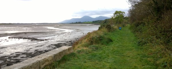
Mourne Walks : Walking along The Lecale Way – Clough to Newcastle, Co. Down, Northern Ireland.
Description
This charming, mostly level walk, takes advantage of the by-gone route of a single-track railway skirting the shores of Dundrum Bay. Passes a world of heritage to visit Dundrum Castle and the quiet country lanes there. Goes on through the National Trust nature reserve and the dunes of Murlough Banks. To finish with a fine stroll along the sands of the sea-kissed littoral and onto the strand at Newcastle.
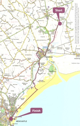
It is a one-way walk, made possible by taking a bus from Newcastle to Clough or catching a taxi for a short trip (allow £10) to the start. See the details below.
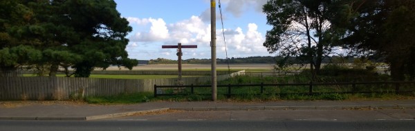
Mourne Walks : Lecale Way – Clough to Newcastle. View from the layby at the bend on the Ardilea Road
Advice
The Route Card: The card describing this route is available in a pack of over 20 walks freely available from the Tourist Office in the Newcastle Centre on Newcastle, Main Street. Titled “Make Your Day – Mourne Mountains – Walking Routes”, this is a great initiative by Newry & Mourne District Council, and I will be reviewing the pack here on Best Walks. For now you may download a pdf of the card here, to assist with your planning.
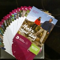
Make Your Day Walking Routes
The Start: Since the start is well away from urban bustle, do make sure you understand where you are going by reading the instructions below.
Underfoot: The route is generally easy underfoot, though a bit bouldery in one shortish field section. There is a brief portion of gently uphill/downhill as you approach and leave the high spot of Dundrum Castle. The road sections are short and not unpleasant or difficult. But you do need to cross the main A2 Dundrum Road twice, so take the usual precautions if you have children.
.
Take with you: This is one of those walks where you can dally a lot. So you might want to take food and drink. Interested in birds? Loads of ’em. Take binoculars and a bird guide. Camera and guide to wild flowers in the spring, summer and even later. Autumn, something to carry the blackberries you’ll pick along the way, whilst watching the migrating waders. Winter, wrap up warm and enjoy the frosty crunch underfoot. A camera at any time. Especially if you’ve an interest in human heritage, history and archaeology.

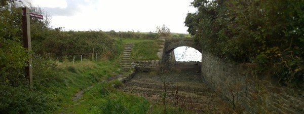
Mourne Walks : The Lecale Way – Your railway embankment route crosses Dundrum Bay
Wayfinding
Wayfinding is generally easy, as the route is well waymarked with Ulster Way and highly visible sign posts. But you will need to keep your eye on the route from time to time, to make sure you don’t miss a turning in the Dundrum area.
- The Lecale Way : From “Make Your Day”
There are a couple of spots where signs seem scarce: The field walking after Dundrum Castle. After you’ve left Moneylane Road the “right of way” is a working bohereen that seems to end with a gate in a field on your right. Ignore the gate and go straight ahead as in the picture below. At the end of the green way make a dog-leg at a junction of field boundaries (in the distance in the picture) and end up on a bouldery footpath with the field boundary on your right.
Finally: If you accidentally emerge at the Orange Hall on the Dundrum Road (instead of The Dam Lane/Derinilla Lane), you’ve missed a junction. Don’t worry the route actually continues a few hundred metres to your left (N) on the other side of the Dundrum road, opposite The Dam Lane. See the signpost picture below. The rest of the route is straight forward, but do use the map on the route card from the Tourist Office.
.

Clough to Newcastle, Co. Down, Northern Ireland. Part of the “right of way” after Moneylane Road.
Getting to Newcastle & The Start
By car & taxi: Make your way to Newcastle, Co. Down. By car it’s a little over 90 minutes from North Dublin and little over an hour from central Belfast. Park in the car-park by the seafront on Downs Road. Or at some other suitable car park in the town. The car-park adjacent to Donard Park at the south of the town (off the South Promenade) frequently has spaces.
Take a taxi to the start: Now make your way to Donard Street, where you will find a couple of taxi offices. Enquire and ask for a taxi to take you to the start of the walk here: The lay-by on the bend by Dundrum Bay on Ardilea Road, Clough. (See the picture above). I was charged £7 in October 2016 and my taxi driver found the place without difficulty. Otherwise ask to be dropped at the junction of Blackstaff Road and Ardilea Road. This is still part of the Lecale Way/Ulster Way and will be waymarked along Ardilea Road until you arrive at the bend and see your route ahead of you. (Again, see the picture above). NB. Metered charges are to be introduced for taxis and prices are expected to increase. Expect to pay £10. Alternatively you can take the bus, from Newcastle to Clough, as described below. (Map ref: 4195 3930).
By bus: If you are travelling by bus, there are Ulsterbus Services from across Northern Ireland, and particularly there are a number of different services between Newry and Newcastle if you are busing-in the from the Republic. You can visit the Ulsterbus journey planner here: http://wlk.re/UlsterbusJourneyPlanner From Newcastle to the start of your walk, you can either take the taxi, as described above. Or you can…
Take a bus to the start: Arrive at, or walk to the Newcastle Bus Station prominent on Dundrum Road/Main Street, (close by the old Railway Station and the entrance to the Slieve Donard Hotel). From there you can take one of several services (20, 26b, 240) to Clough. Alight at Clough town centre and head roughly east on the Blackstaff Road for about two-thirds of a mile until you reach the junction of Blackstaff Road and the Ardilea Road. This is the Lecale Way (Ulster Way). Follow the Ardilea Road until you arrive at the right bend and see your route ahead of you. (Map ref: 4195 3930).
You can visit the Ulsterbus journey planner here: http://wlk.re/UlsterbusJourneyPlanner
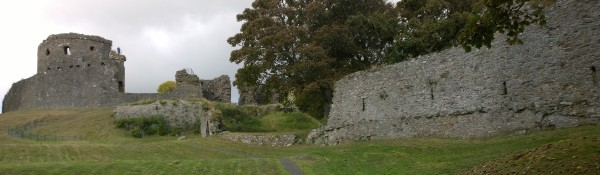
The Lecale Way: Clough to Newcastle – Dundrum Castle
Alternatives and Variations
Option 1: Shorten the walk by starting from Dundrum. Walk South out of Dundrum centre on the A2 towards Newcastle. Look for the signpost directing you left, away from the road, to Murlough Nature Reserve and the Downshire Bridge (Map ref: 4015 3605). The signpost is shown in the picture below.
Option 2: Begin the walk. On arriving at Dundrum do not cross the A2, but walk into the town, to avoid the detour to the castle and inland. Instead find somewhere for a long lunch in the town and rejoin the route on the Dundrum Road as described in option 1 above.
Option 3: Take a bus or a taxi to the picnic area & car-park at the Slipperyford Bridge. Cross the road enter the track leading to the nature reserve and fork right to pick up the walk through Murlough Banks and along the littoral and strand back to Newcastle. (Map ref: 3955 3415)
Cross or leave the A2 South of Dundrum. And follow the path by this signpost across Dundrum Bay
Language & Landscape
Being Anglo-Irish and having spent a lot of my childhood in Derbyshire, I know how they say “Clough” (as in “cluff”). And one of my favourite spots from my youth on Bleaklow is the upper reaches of Lynch Clough. But Irish spelling and pronunciation is different even in the North. And Clough is pronounced more like “Clock” even than the Scottish “lough” (lake), though you will hear both. It’s an anglicization of the Irish “cloch” and means a stone, don’t forget it.
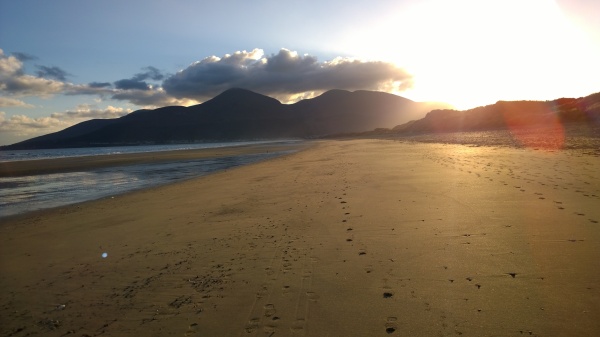
Mourne Walks : The Lecale Way – Clough to Newcastle. The final stretch of delight
Sharing is brilliant. It rewards me for my effort and encourages me to do more. Please share...

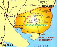
Harvey Maps Superwalker : Mourne Mountains
The moment you open up this map you know it’s designed for Mourne walkers. 1:25000 scale, printed one side only, in landscape mode, with the principal fold made vertical. Open one way and you are looking at the Eastern Mourne, open the other and you are looking at the West. Most popular walks fall between a couple of folds.
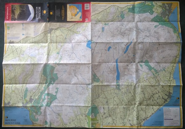
Harvey Maps Superwalker : Mourne Mountains -after 8 days of intensive use in the wet, without a cover.
The second thing that strikes you is the use of strong and bold colour, and then you immediately realise that the mountains and bogs are clear and uncluttered, the critical detail legible and explicit on a white background.
Eventually the feel of the paper between your fingers, seems a little curious, so you check out the web site and it tells you it’s printed with a hi-tech process designed to resist damage from wet.
And your confidence about going somewhere fresh and new, starts growing…
Accuracy, Clarity & Durability
Not so much ABC as ACD – Accuracy, Clarity and Durability. They are my three expectations of a map for walking in any mountains. So obvious they don’t really require any elaboration. Although it’s worth understanding that they all fit together. For example, the size of the map is going to impact both its clarity (such things as scale) and its durability (folding and unfolding, and workable squares). And even accuracy gets impacted by scale, when a saddle in a ridge may fail to appear in the contours, or a spur has its shape maligned and easily-read spot-heights become important.
Here then is my list of pro’s and con’s of the Harvey Superwalker Mourne Mountain Map, written with those three qualities in mind…
Pro’s
Even on your first walk it will quickly become clear that this map is designed for easier use and easier reading when you are out on the mountain. And I explored this in some detail with a Twitter Quiz: What makes “this” map easier to read. Here’s my summary from the quiz answers:
They’ve thought about:
- How many lines should go on the map and what they should be used to represent. Making sure there are enough to give you adequate information, but not so many as to clutter your view. The same approach has been taken with text and reducing the naming of features in the landscape. It’s all about reducing clutter.
. - There has been a careful consideration of the use of colour. Block colours identify lowland areas, forestry and water. But the more hazardous mountainous areas are left white, to allow emphatic and bold use of contours. And coloured patterns too, used to illustrate some quality of the landscape underfoot. Whilst the technical opportunity to change the colour of a contour is used to show a change in conditions.
. - Even the best manner of folding the map. And using the folded map, has been considered. But especially important, is the ability to see the Eastings and Northings figures of the 1km squares of the Irish map grid. Great for those who thumb their way along the map as they walk, and for when the wind makes it impossible to open up your map and take readings from the edges.
. - You can find the examples of these features and the full explanation here
Of course, as you’d expect from a map manufacturer of this quality, it has all the usual features, map key, distance scale for miles and kms, GPS compatible grid, grid references and magnetic declination (variation) and rate of change for a given date.
Con’s
Don’t think of this as something that you buy and keep. It’s not a long-term investment. It is a “consumable”. It’s designed to be used, and it will wear out – though not as quickly as others you might own. So use it. Treat it like a good pair of wool walking socks. Once it’s begun to acquire holes, expect to replace it.
.
 Best uses
- Learning to read a map for walking in the hills
- Winning freedom from the tyranny of the footpath or your pal who “knows the way”.
- Finding new routes with it’s uncluttered presentation of the landscape.
- It’s also ideal for planning exploration over open mountain.
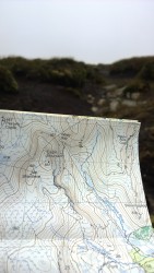
Using the map in poor visibility – Finlieve
Useful links…
Harvey Maps home web site
Harvey Maps product page for the MOURNE MOUNTAINS SUPERWALKER map
All Harvey Maps – Map Specifications
Download the Harvey Maps Map Legend (Map key)
The Best Walks Twitter Quiz – Questions only
The Best Walks Twitter Quiz – Questions & Answers
.
Where to buy
Harvey Maps SUPERWALKER MOURNE MOUNTAINS from Harvey Maps online
Harvey Maps SUPERWALKER MOURNE MOUNTAINS from Stanfords online
Harvey Maps SUPERWALKER MOURNE MOUNTAINS from Amazon.co.uk
Sharing is brilliant. It rewards me for my effort and encourages me to do more. Please share...

#NationalMapReadingWeek : The Twitter Quiz – Answers
It’s one thing to sit at the kitchen table one weekday evening with the map spread out in front of you as you delight in planning your next Sunday walk. You’ve plenty of light to see-by. The minor draught coming through the kitchen door is nothing compared to the 50km winds you might experience walking along a ridge. And assuming your roof is in good order you are likely to be warm and dry.
It’s quite another when you are actually out there. The cloud base has dropped. An unexpected front has passed over, the temperature has fallen, humidity risen and it’s started to rain. Your companions want to cut the walk short, and you need to look at the map and find a safe “escape” route quickly.
What makes this map easy to read..?
To help you discover how a map is made so that you can work efficiently in those conditions, I asked five other questions, each one focusing on one bit of map detail. Looking at those and the answers should help us to discover why the map is drawn this way. And what makes one map more suitable than another when you are out on the mountain. So read on…